Major Commodities: Gold, Pyrite
Trace Commodities:
Host Rock: Quartz, Diorite
Legal Description: 36 South, 3 West, Section 15, NE 1/4
Elevation: 1280 feet
The Bull of the Woods mine consists of 31 acres of patented land located above the east side of the Rogue River on the western slope of Gold Hill. Very little is known about the mine prior to the 1930's except for the fact that the property was originally patented as agricultural land in the 1880's by Francis Marion Fredenburgh who was a prominent businessman in the Gold Hill area until a few years prior to his death in 1903. There is no indication that Fredenburgh engaged in any mining on the property or any indication of when mining began on the property, although it is certainly in a desireable area due to its close proximity to the famous Gold Hill Pocket.
In 1934, J.A. Clements leased and operated this property for two years, producing close to 145 ounces of gold. In 1936 and 1937, George Tulare operated the mine but production figures are unavailable, if any actually took place. In the Fall of 1938, Clements again secured the lease and began to drive a second shaft about fifty feet south east of the oldest workings. At the time, the property was owned by Mrs. Vella Hays of Gold Hill and Mrs. Rena Davis of Fort Klamath, California.
Reporting in January of 1939, J,.E. Morrison informed the State Department of Geology that there was a good road into the mine and that the topography consisted of rolling hills. Next to no mining timber was available on the property and no water was available with the exception of about 130 gallons per hour which was produced by seepage in the mine itself. Equipment at the mine included a 7 X 8 Chicago pneumatic compressor that was powered by a 4 cylinder Liberty engine, a small air powered Denver Gardner steam hoist, one ore car, an air hammer and misc. small equipment. Sometime during February or March of 1939, Clements installed a two stamp mill.
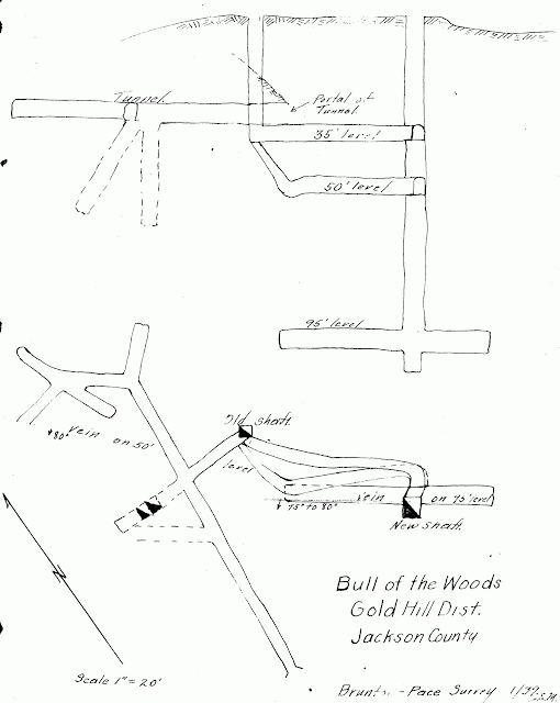
Development inside of the mine iconsisted of a total of 266 feet of workings, which did not include a vertical shaft 100 feet deep with three levels at the 35, 50 and 95 foot marks. The 35 and 50 levels connected to the mine's oldest workings, while the 95 foot level consisted of one drift that ran North 55 degrees West for 35 feet and another than ran South 55 degrees East for 25 feet. About fifty to sicty feet south west of the main shaft, a 105 foot tunnel with eight drifts ran North 5 degrees East.
According to reports, the dark country rock is: "probably diorite. (The) vein appears to be aresilicified shear zone from two to six feet wide and is composed of quartz and wall rock which breaks free from the hanging wall. (It is) difficult to determine how much of the foot wall should be mined. The values pentrate the walls. A sample cut for for 25 feet along the hanging wall on (the) 95 foot level runs $1.05 (at $34 per ounce). Samples from (the) foot wall run trace to $2.45. The 95 foot level has not tapped the ore shute (sic) found in the upper levels. (The) vein is of good mineable width. Its lateral extent is not known. Ore mined from the upper levels plated $10 per ton (at $34 per ounce). (The) vein dips from 75 to 80 degrees to the south east and strikes North 55 degrees West. (The) ore minerals are pyrite and free gold, estimated 50% free milling."
Nothing is known about this mine after 1939 and it is presumed to have been shut down in 1942 by Limitation Order L-208 and to have never been re-opened.
Sources:
Oregon Metal Mines Handbook: Jackson County, 1943, pg. 57
Unpublished State Department of Geology Mine Report, March 16th, 1939
Obituary of "Francis Marion Fredenburgh", The Medford Mail, Eagle Point Eaglets, June 12th, 1903
 |
| From the forthcoming "Gold Hill Mining District: Mines & Mining in South West Oregon" by Kerby Jackson Copyright 2010 by Kerby Jackson |
